How Drone Are Leveraging LiDAR Cameras
Drones & Lidar
Modern commercial drones have evolved from what was mainly a flying camera into powerful data collecting tools. Standard Red Green Blue (RGB) cameras represent the most basic payloads for drones. Another step up in capability and cost are thermal and multispectral cameras. Even higher up are lidar (Light Detection and Ranging) scanners.
High-quality lidar systems are not cheap, but the technology's power is worth understanding and considering for your operation. Some incredible advancements are occurring in both the commercial sector and in academic research, thanks to lidar.
Lidar has numerous applications in the UAV world. You may already be familiar with lidar as a payload but may not know it is used to aid in other functions like obstacle avoidance. For this article, we will focus on lidar as a payload and ignore other uses for the technology.
Our discussion will cover what lidar is and how it works. We'll then review a few platforms on the market and finally review some of the ways lidar has been used with great success.
What is Lidar?
Like many technologies used by the UAV industry, lidar was invented long before the modern drone age. In 1961, Hughes Aircraft Company developed the first prototype lidar system. Coincidentally, one year earlier, the company created the first laser as well.
Much of the early uses for the technology were related to space exploration. The first systems were laser altimeters used by NASA. Lidar was used for some impressive endeavors, such as mapping the moon on the Apollo 15 mission in 1971. In 1992 the first space-based lidar system was part of the Mars Observer program followed in 1997 as a part of the Mars Global Surveyor.
As we will later learn, a critical component of lidar for UAVs is the incorporation of GPS. The Department of Defense invented GPS in 1973 but the technology only became available to the public in 1983. It should be noted that the military uses an encrypted version of GPS that is much more accurate than the version we use in our daily lives.
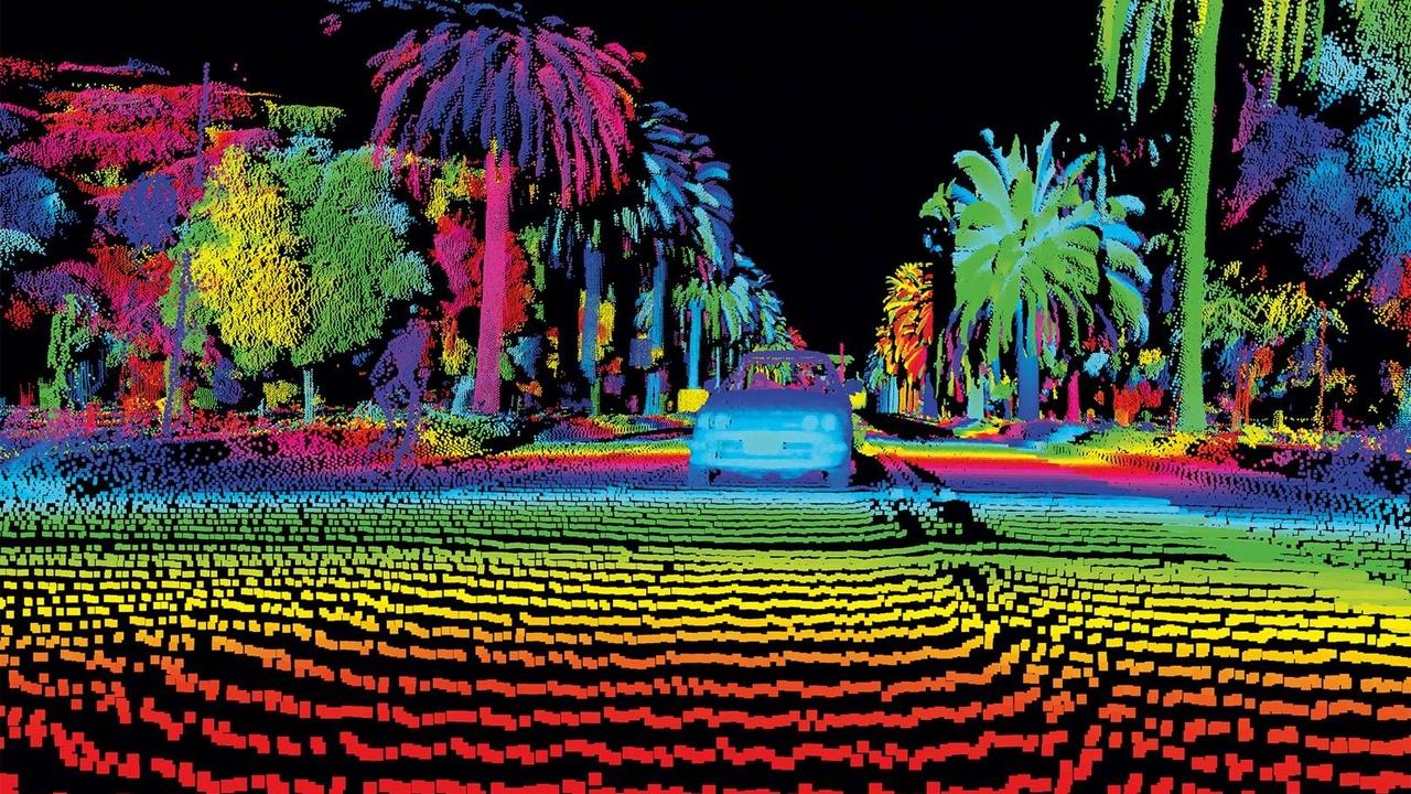
Lidar combines a laser, scanner, and specialized GPS receiver (along with computing equipment) to measure or map the area to be scanned. You probably remember the classic toy where a collection of sliding metal pins arranged in a rectangle can take the form of the object the pins were placed over, such as your hand or face.
If you imagine each of these pins to be a laser firing from a lidar scanner and the object under the pins to be the terrain that is being mapped, you can get on idea of what lidar is.
How Lidar Works
Lidar is a method of remote sensing. The technology is divided into two categories: terrestrial and airborne systems. As the name implies, terrestrial lidar is deployed on the ground. Terrestrial lidar can be either mobile or static. An excellent example of the mobile version is Google's Street View car. The latest version has two lidar sensors mounted under the camera. Static lidar is typically seen on a tripod used in surveying.
The second type, airborne systems, are more important to the commercial drone pilot. Airborne systems can be topographic or bathymetric. Topographic systems are used to map land and are equipped with a near-infrared laser, in most cases. Bathymetric systems map riverbeds or sea floors and use a green laser that can penetrate water.
A complete lidar system can be broken down into the following components: laser, scanner, GPS receiver, IMU, timing electronics, and a computer processor.
The laser is responsible for the beam of light fired at the object being scanned. The scanner is what picks up the reflection of the laser once it is bounced back from the object it was fired at.
A specialized GPS receiver and an Inertia Measurement Unit (IMU) work together to record the lidar system's position three-dimensionally. Timing electronics also assign an exact time to when each laser pulse leaves the system and when it returns.
Finally, the computer is responsible for taking all the data collected and processing it. In most cases, this generates a point cloud in a three-dimensional field.
During scanning, the laser of a lidar system is fired well over a hundred thousand times a second. Each time a laser is fired, it can generate one or more points. In some cases, a single laser can return to the scanner more than once. For example, say a laser is fired and hits a tree. The beam of light can reflect off of several different branches and the ground. Lidar systems fire lasers straight up and down and also at angles resulting in millions and millions of points generated during a flight.
Let's look at the steps for generating a single point using lidar. First, a laser is fired at the ground. The GPS, IMU, and timing electronics record the exact position and time the laser was fired. The laser hits the object and bounces back to the lidar system where the scanner receives it. Again, the GPS, IMU, and timing electronics record this moment and position.
This process happens again and again as the scanning continues. Using an equation which leans heavily on the constant speed of light, the computer processes all this data into a three-dimension map, and what we are left with is a highly detailed rendering of the scanned space.
Due to the multiple reflections from a single laser shot and scanning at angles, lidar can see the sides of objects and even remove layers, such as vegetation, from our view.
Lidar Platforms
Most lidar systems are not cheap. When you think about the different components we discussed earlier and the accuracy needed to render point cloud maps, it is no wonder these systems are expensive. Low-end systems can set you back thousands while high-end systems rival the cost of some single-family homes.
If you search for lidar systems, you will often find the cost listed as "request a quote." This is never a welcomed sign for the budget-conscious commercial drone pilot. Keeping in mind, you can charge top dollar for this type of service; perhaps the investment can be factored into your business plan. I'll mention one sensor as an example and one turnkey system. If you are interested in buying a lidar system, speak with professionals before buying anything specific.
One of the more established manufactures in the space is Velodyne Lidar. The company has been around since 1983 and manufactures the HDL-32E High-Resolution Real-Time 3D Lidar Scanner. The sensor has an accuracy of +/- 2 cm and features a rugged design with low power consumption ideal for UAV use. You'll need to contact them for a quote, but used versions are for sale on eBay for $20,000 to give you an idea of the cost.
Dronefly sells a turnkey lidar UAV system. The Geodetics Matrice 600 Pro Turn-Key LiDAR Drone can be equipped with Velodyne's HDL-32E scanner. You can order less accurate scanners with +/- 3 cm accuracy as well. The base Matrice 600 costs around $5,500. I’d assume the complete system might range between $25,000 to $40,000 or more.
It is best to contact a dealer, such as Drone Nerds, and make sure you are getting the right sensor for the applications you want to use lidar for before making a purchase.
Lidar Uses
For the commercial drone pilot, many of the projects you can work on with lidar payloads will fall into one of the following five fields: topographic mapping, forestry, high-level precision utility inspection, hydrology, and archeology.
Topographic mapping can be accomplished with a standard RGB camera, but there are limitations to this type of photogrammetry. If you have ever used an RGB camera to take pictures of a city, you know you often cannot see the sides of buildings or through dense vegetation. Lidar can handle this with ease.
As mentioned earlier, a single laser beam can reflect multiple times. This fact allows professionals in the forestry industry to use drones and lidar to understand a forest's structure better. Trees can be mapped out without rangers every stepping into the area. Remote sensing of this kind can assist conservation efforts and head off potential ecological disasters.
Utility companies are investing heavily in drones and lidar. Here again, is another field where standard RGB photogrammetry isn't always the ideal tool. If the object being inspected is small, an RGB camera might not provide enough detail. Say, for example, a utility company wants to map out all their powerline locations in a dense city. RGB cameras would have difficulty getting the detail needed for this task. Lidar, on the other hand, can generate the level of precision necessary to complete such a project.
Mapping areas such as riverbeds and the seafloor are excellent uses for lidar. Bathymetric lidar can penetrate water and reveal crucial details needed for studying flood patterns, erosion, and planning construction projects. Drones are becoming especially useful to hydrological studies designed to update flood maps, which in some cases may be still be based on decades-old data.
A final area for UAVs and lidar is archeology. Lidar's ability to layer the environment is rewriting the history of many civilizations as we know them. If you are interested in this field, I highly recommend checking out National Geographic's coverage of how lidar is revealing previously unknown Mayan cities in Central America. The technology is perhaps the most important tool for researchers to have come along in the last several decades.
While the cost can be significant, lidar payloads can bring your UAV business to the cutting edge of commercial drone operations.

Join Our Private FB Group Community
Access to training, education and drone industry news. Meet other like-minded drone enthusiasts, just like you!
Online Part 107 Test Prep Course | Sale
Recent Posts
